![]()

|
county list
|
| Court-tombs = Portal-tombs = Wedge-tombs = Passage-tombs = Stone Circles | France | |
|
|
Tell-A-Friend
|
SELECTED MONUMENTS IN
Place-names in italics refer to listed entries.
Ardamore: Stone-row
400 metres N of a by-road, and 7.5 km E by S of Dingle, the highest stone of this 3-stone row (plus outlier) is 3 metres. The Dingle Peninsula is littered with monuments, mostly cross-pillars and standing-stones, and it would take at least three days non-stop to visit everything worth seeing. ~ 500 metres SW, in Aghacarrible (V 511 997) 20 metres S of a by-road, in a field entered by the leftmost of two field gates, and on either side of the right-hand field-fence, is a large boulder with cups and rings, gutters, and other typical designs. ~ 700 metres SSW in Doonmanagh (V 525 996), 150 metres W of a rough track zig-zagging down towards the sea, is a wedge-tomb, lurking behind a wall about 300 metres SW of a radio transmitter, but visible from the road which passes the mast. "Poukauncorrin" (The Fairies' Cave) is a small well-preserved tomb. At least one sidestone has been removed from the NW side, together with some of the cairn, to provide access and make the tomb a snug shelter or habitation ( cf Haroldstown in county Carlow). The site affords superb views to the W and NW, and to the E and SE towards Magillicuddy's Reeks. ~ About 400 metres NE of Doonmanagh (Q 532 003) to the N of the narrow winding road which passes the transmitter in Graigue is a remarkable tall standing-stone split vertically in two, one piece leaning on what appears to be the remains of a second stone.
~ 9.5 km W by N, 800 metres ESE of the village of Milltown (Q 429 010), almost opposite the graveyard and to the W of the road from Dingle to Ventry, on top of a low cairn is a boulder almost 4 metres long, decorated with cups and circles and grooves. Nearby are standing-stones, and another boulder with markings. To the N are the two 'Gates of Glory' standing-stones (one broken), and 40 metres W, by the roadside, is another standing-stone 2.4 metres high. ~ Just under 2 kms E by N in Lugnagapull (Q 542 003), marked Clocha Ogaim on the map, in a field close to the road called "Pairc na Foladh": the Field of Blood, is a line of three remarkable Ogam stones which are small, smooth pulvinars, one of which is beautifully egg-shaped and reads GOSSUCTTIAS . As is frequently the case with Irish monuments, there are white quartzite pebbles at the base of the stones.
~ 10.7 km WNW in Kilfountan (marked Gallán on the map) is a fine conspicuous standing-stone, visible from the by-road to the E, and from the Early Christian site (350 metres SW) with a superb cross-decorated pillar which bears the name of the saint: Finten.. The Dingle peninsula is littered with Standing-stones (marked Gallán [singular] and Galláin [plural] on the map), as well as a rich variety of Early Christian sites with cross-pillars, Ogam-stones, cross-slabs, circular stone huts [ Clocháns ] etc. Almost all are clearly marked on the map. Some more sites are listed below.
Ballynahow Beg: Petroglyphic boulder
Behind a house to the S of a by-road, 7 km NE of Cahirsiveen (marked
Rock Art
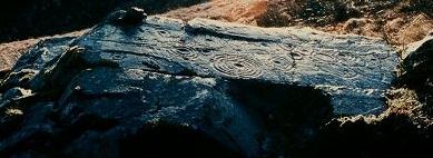
on the map), in the second field (50 metres) from the road, to the W of a hedge and bank is a boulder whose exposed E face is 135 cm long and 81 cm high, decorated with Bronze Age motifs such as ringed cupmarks with 'tails' or 'gutters' (looking a little like frying-pans with fried eggs), un-ringed cupmark, and a grid of grooves. It is unusual for petroglyphs to be carved on the vertical face of a boulder.
~ 10.5 km ENE, in Coomasaharn (V 632 852) near the N end of Coomasaharn Lake are several horizontal rock surfaces decorated with circles, lines, cups and rings. The best surface is 100 metres W of a modern bungalow at the end of the tarred road.
~ 12 kms NE in Coolnaharragill (V 633 886) in the front garden of (the former ?) Jackson's guesthouse to the S of the Cahirsiveen-Killorglin road, is a boulder decorated with cups and rings. In the same townland is a stone fort or cashel with an S-shaped souterrain. ~ 25 kms ESE are several petroglyphic boulders at Derrynablaha . ~ Almost 10 kms WSW is Leacanabuaile stone fort and other forts nearby.
Coom: Wedge-tomb
The picturesque
"Labbydermot"
lies 200 metres S of a road-junction, 3.3 km NW of Ballinskelligs. This well-preserved and picturesque tomb's main chamber is covered by a capstone just under 3 metres long. There is an opening in the narrow E end which may be original. The antechamber/portico is unroofed and made with high slabs, the largest being 1.5 metres high. There are two closing-slabs with a deliberate gap in the N side.
Derrynablaha: Petroglyphs
1.5 km E of Lough Brin, scattered over a wide area to the E and W of the road through the beautiful Ballaghabeama Gap, and surrounding the only inhabited house (in 1975) for miles, are over 20 decorated rocks. They are very difficult to find on the boulder-strewn hillside, but perhaps the easiest to locate are those for which the grid reference above is given, found by following the S branch of a stream from the bridge about 300 metres S of the abovementioned farmhouse, then up the hillside for about 400 metres. A prominent table-like rock a short distanced S (left) of the stream - and visible from the road - is decorated with numerous cups and penannular rings and grooves. beside it is a small rock whose vertical (W) face is decorated with the rare motif of cups and rings surrounded by a ring of small cups and a large indented ring, similar to those at Ormaig in the Kilmartin Valley of Argyll.
About 200 metres E of these, about halfway between them and the second bridge (200 metres SE of the first one) is a low altar-like rock with a curious design of cup-marks and irregular, roughly-circular grooves. ~ 9.7 km SE (6.4 km WNW of Kenmare ) just 20 metres W of a by-road, in a field just S of the (?former) Downings' house at Poulacapple in Rossacoosane , is a single boulder (not marked on the map) with a curious and interesting pattern of grooves and cups & rings.
Drombohilly Upper: Stone circle
2.4 km NE of Lauragh Bridge and 350 metres E of a by-road from which it is visible, this fine stone circle crowns a knoll and offers magnificent views. It is unusual for the pillar-like stones used in its construction. Nine stones out of a probable 11 now remain (one of the missing stones being the 'axial' or 'recumbent'), enclosing an area over 8 metres in diameter. A short distance to the E is a rectangular grass-covered stone-built mound which may have something to do with the circle.
~ 5.6 km SW, in
Cashelkeelty East
(V 748 575) , 800 metres S of the Lauragh-Castletownberehaven road and 3.2 km WSW of Lauragh Bridge, are remains of a 5-stone circle beside a rock outcrop. Immediately S of the circle are 3 outliers in a line over 6 metres long. The site, as is to be expected, commands impressive views. To the S and E are traces of prehistoric field-walls. 150 metres W are remains of a probably stone-row. Immediately N of these sites, the mediæval road from Kenmare to Castletownberehaven is still discernible as a wide, grassy track.at least
~ 6 kms NE, in a beautiful setting between the two loughs of Cloonee and Inchiquin at Uragh (V 832 625), is a fine 5-stone circle, with a blade-like axial stone and a huge outlier 3 metres high.
It affords splendid views, as does the second stone circle in the townland (V 825 630), 800 metres to the SW . Difficult to find among the bushes, eleven low stones surround a central boulder-burial and an off-centre quartzite boulder. Outside the circle are two more quartzite boulders. ~ 6 kms SW is the fine circle at Dromroe (V 882 658). ~ 4 kms SSW is a rare Irish "four-poster" stone circle mysteriously hidden in a grove on the island of Knockcappul in the Kenmare estuary (V 768 577). It is accessible only at low tide. A gallows stood here also in the 18th century. ~ 6.4 km SW of Dromobohilly and 2.4 km SSE of Cashelkeelty is another stone circle in Shronebirrane (V 753 554). Some 7 metres in diameter, it is 4.8 km SW of Lauragh Bridge and visible to the right of a road leading up a dramatic glen towards Eskatarriff and The Pocket. Eight tall stones out of a probable 13 survive, set unusually close together. Opposite the tallest (entrance or portal) stone is the axial stone, with a straight top edge. The other entrance-stone is missing. ~ 9.6 km SW is the superb circle at Ardgroom Outward in county Cork.
Dromatouk: Stone circle, etc.
4.8 km ENE of Kenmare and about 350 metres above the road which follows the Roughty river on its S side, is a neat little 5-stone circle. 220 metres SW is a low cairn some 7 metres in diameter with a single pillarstone 3 metres to the N of it. 400 metres NE of the cairn is a group of three standing-stones not in line, the highest and midmost bearing on its cracked and fissured surface an Ogam inscription which has been interpreted as TAGNILOCID MAQI ALOTTO. ~ 5 km ESE is the stone circle at Gurteen .
Dromroe: Stone circle and Boulder-burial
About 5.6 km SW of
Kenmare
, approached via a track leading SW from a by-road, above a farm, a very picturesquely-sited circle encloses an area over 9 metres in diameter. Three of the 13 stones (including one of the entrance- or portal-stones) are fallen. In the centre is a boulder-burial set with its long axis coinciding with that of the circle whose flat-topped axial or recumbent stone is at the SW. The three supporting stones are also flat-topped, and between them and the large covering-stone are chocking-stones. Nearby is an unique internal monolith.
Dunbeg: Promontory fort
click on the thumbnail for a larger picture
3.2 km E of Slea Head on the Dingle Peninsula, and S of the road in the townland of Fahan, across a field, this fine fort is a triangular headland defended on the landward side by a massive, restored dry-stone wall with elaborate entrance and internal terraces, and to seaward by high, eroded cliffs. The side-walls of the long, lintelled entrance are recessed to hold sliding defensive beams, and have guard-chambers on each side with squint-holes for surveillance of the passage. From below the passage a long souterrain leads out at least as far as the second of 4 parallel defensive stone-faced banks with ditches. Inside the fort are remains of a large circular stone hut (clochán) with a square interior. From it a stone drain leads to the cliff-edge, where some traces of a curtain-wall survive.
~ Between Dunbeg promontory fort and Slea Head are many stone forts containing circular stone huts or clocháns of one, 2 and 3 chambers, especially in the contiguous townlands of Fahan and Glenfahan. Unfortunately, many locals are charging the unwary to cross their land to see them.
Eightercua: Stone-row
On the crest of a ridge to the E of the main road 1.6 km SSE of Waterville, 4 tall slabs from 1.8 to 3 metres high run from E to W. From one of these an orthostatic slab runs S and looks like part of a tomb-chamber or a kist set in an oval cairn 1 metre high. The association of standing-stones with cairns is not uncommon in Kerry.
Feaghna: Bullaun
8.8 km SE of
Kenmare
, to the S of a ruined church which is to the N of a by-road is a remarkable smooth-topped boulder with 8 hollows in it, ranging from small cup-marks to hemispherical basins about 30 sms across. The larger ones carry oval stones latterly known as 'butterlumps' . These are turned in their basins in the final stages of the Easter 'pattern' or
'turas'
which includes a well to the E of the church, and part of the church wall. The
'patrún'
or 'pattern' is evidently of extreme antiquity - as indeed are most in Ireland - going back at least 2000 years. In the middle of the boulder a cylindrical stone of phallic shape stands in a circular holed stone.
~ 9 kms WNW is Dromroe stone circle. ~ 12 km SSE in county Cork are Mill Little stone circle and boulder-burials.
Gurteen: Stone circle
9.5 km E of Kenmare and 3.2 km S of Kilgarvan, to the S of a track, on a ridge to the N of the Glashagoruv river, the eleven stones of this circle (10 metres in diameter) are set in splendid landscape. The large axial or recumbent stone has a bevelled top edge. Opposite it, two portal-stones lurch to the E. A large boulder stands in the middle: the capstone of a boulder-burial. Two stones stand outside the circle to form a kind of approach-passage, as at Gowlane North in county Cork. ~5 km WNW is the five-stone circle at Dromatouk.
Kenmare: Stone circle and Boulder-burial
On the SW outskirts of Kenmare, 600 metres SW of Cromwell's Fort (a 17th century castle), stand fifteen stones (two prostrate) which enclose an oval area over 16 metres across, in the middle of which is a good example of a boulder-burial comprising three small stones and a large capstone.
~ 3.2 km NE of Kenmare in Gortagass , down a lane to the NW of the road to Kilgarvan, just on the other side of the dismantled railway is Cloch a Caipín , a presumably natural curiosity (not marked on the map). A very large round boulder sits neatly on a large cylindrical boulder - resembling a giant mushroom.
Kinard East: Ogam Stone
Half-buried at the W end of the old graveyard is a rounded pulvinar stone similar to one of the stones at Lugnagappul (almost 5 kms ENE). On the side is a well-cut ogam inscription reading MORIANI, while on the E face is a large square divided by a cross. ~ About 250 metres SE of the pulvinar, in the second field above a group of cottages to the right of a track, is a stone decorated with grooves and cups, many with rings. During field clearance it was moved to the edge of the field so that the petroglyphs are now invisible and protected on the lower surface!
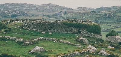
Leacanabuaile Stone fort
Prominently sited on top of a massive rock, 3.2 km WNW of Cahirsiveen, this fine stone fort has a reconstructed dry-stone wall 3 metres thick (but now only 1.2 metres high), adapting to irregular outcrops of rock. There is a wall-entrance on the SW and remains of 2 terraces on the NE. Steps lead up to them at 10 points. There were formerly 3 beehive-shaped huts inside, but only one survives, with a (later) square house built against it and on top of the ruins to two other houses. The round house abuts the wall of the fort, and from its doorway a hole in the floor leads into a souterrain some 10 metres long, ending in a wall-chamber. There is another wall-chamber, entered by a short passage, in the NE part of the wall. ~ 300 metres N of Leacanabuaile is another stone fort called Cahernagat (Cathair na gCat) . ~ 400 metres SE of Leacanabuaile is Cahergal, a fine but ruinous stone fort, in the centre of which is a large oval dry-stone house withy walls surviving to a height of 1.5 metres. ~ Just over 8 km SW, in Cool East (V 373 755), N of the northern (minor) road leading SW from Knightstown to Bray Head, is Killadreenagh, an ancient burial ground with an Ogam pillar some 1.9 metres high, engraved with a Latin cross. About 100 metres NW of this, on higher ground,
is a low wedge-tomb with a portico and a single capstone measuring 3 by 2.5 metres. South of the road is another Ogam pillar. There are several pillarstones and an alleged (but dubious) stone circle in the landscape to the E. ~ Almost 10 km ENE are Ballyanahow Be g petroglyphs.
Lissyviggeen: Stone circle and outliers
Only 3.2 km E of Killarney, this too-well-known seven-stone circle within a low surrounding bank of earth (beyond which stand two large outliers) is now closed to visitors, due to the amount of litter and other depredation.
Staigue: Stone fort and Petroglyphs
This well-known and restored fort 27 metres in diameter, is splendidly situated at the head of a valley opening S to the sea., and is surrounded by a ditch over 8 metres wide and, at present, 1.8 metres deep. The massive wall reaches a height of almost 5.5 metres and is about 4 metres thick at the base, tapering to about half as thick at the top. Vertical joints in the walls show that gaps left to allow access of carts etc. during building were filled in later. The doorway is tapering and lintelled. Inside is an elaborate system of stairways leading to terraces, and corbelled cells in the wall reached by passages. ~ About 800 metres S of the fort and about 100 metres E of a disused bridge (beside which the road bends to the W) is a large outcrop of rock, visible from the bridge. On it is a fine series of cups and circles and grooves extending for 12 metres along the rock surface.
~ 7.2 kms SW, just 800 metres W of Caherdaniel hamlet and about 200 metres W of the road to Waterville is another stone fort, beautifully situated on a commanding outcrop of rock, whose switchback irregularities make the construction most impressive.
Its walls are up to 4.5 metres high and enclose an area 25 metres in diameter. ~ 3.2 km W by N of Caherdaniel, close by the main road to Waterville, near the summit of the Coumakista Pass, is "The Boardeen" (Little Table), a conspicuous but denuded wedge-tomb, whose dramatically-tilted capstone is 4 metres long by 2.4 metres wide and 1.5 metres thick. There are no fewer than three other wedge-tombs in the same townland . |
![]()