![]()

|
county list
|
| Court-tombs = Portal-tombs = Wedge-tombs = Passage-tombs = Stone Circles | France | |
|
|
Tell-A-Friend
|
SELECTED MONUMENTS IN
Place-names in italics refer to listed entries.
Aillemore: Court-tomb
This fine and well-preserved megalith, some 8 km WSW of Louisburgh, near the crest of a ridge overlooking the valley of the Bunsheenshough river, is visible 300 metres WNW of a track. It comprises a 2-chambered gallery and a small subsidiary chamber behind it. The cairn rises to the top of the gallery-stones (about 1.5 metres high) and is over 16 metres long by 14 metres wide. The court is obscured by cairn material and field-fences. The outstanding feature of the tomb is the steeply-pitched, packed corbelling of large slabs on the gallery, especially on the N side. The subsidiary chamber is almost concealed by corbelling and by stray débris from the cairn.
Ballyglass: Court-tomb
In a field to the NE of a by-road, 1.2 km from Ballycastle, this fine and large monument - over 27 metres long - has an elongated central court 12 metres long by over 7 metres wide, giving access to a twin-chambered gallery at each end. Just one lintel survives in position, while two others have slipped into each end of the court. Excavations showed that the tomb had been built over part of the remains of a Neolithic rectangular timber house: a booklet on the excavation might be bought in Ballycastle.
About 200 metres S is a ruined full-court tomb which has a false entrance of jambs and flankers on the N side of the court, as well as a true entrance. ~ 5 kms NW, approached by the R.314 to Belderg are Céide Fields (with visitor centre): a complex of Neolithic field-walls and other structures including tombs.
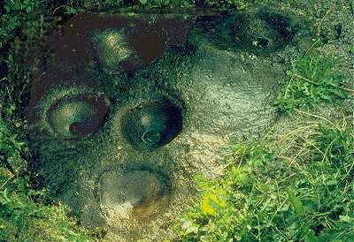
Boheh: Petroglyphs
6.5 km SSW of Westport, behind a house on the W side of a narrow by-road to the E of Boheh Lough and the Westport-Leenane road, a roughly-circular outcrop of rock known as "St Patrick's Chair" is covered with many cup-marks, concentric rings, and maze-motifs over an area 3 metres across.
~ 1.3 km NE in Lanmore is 'Clogh Phadraig' or St Patrick's Stone: one of several standing-stones in the area. ~ 4.8 km NW in Killadangan , 2.5 km E of Murrisk Abbey, in a field known as Gortbraud to seaward of the road to Louisburgh, opposite a lay-by, is a marshy field scattered with standing-stones of various heights - one picturesquely surrounded by water. There are remnants of a double stone circle (?) 12 metres in diameter, a line of small boulders near thje road which may be the remains of a large oval enclosure, and an alignment of 4 stones of decreasing height, of which the tallest is 1.2 metres high, and broken.
Bracklaghboy: Ogam stone
In the townland of Island , in the centre of a round mound to the E of a by-road, is a stone (known as "Lisvaun") 1.8 metres high and leaning backwards, which has the worn inscription CUNALEGIAV QUNACANOS
Breastagh: Ogam-stone
Almost 5 km NNW of Killala, to the W of a by-road leading to Lackan Bay, this large, square-sectioned stone almost 2.5 metres high was very probably a Bronze Age standing-stone later adapted for memorial inscription in Ogam. On one side the defaced inscription LEGG SD LE ESCAD can be made out. On the other: MAQ CORRBRI MAQ AMLOITT ('maq' is the modern Irish 'mac' meaning 'son').
~ About 1.6 km S, on the W side of the road to Lackan Bay is a very accessible (though ruined) double-court tomb in Carbad More . At either end of the remains of a cairn are the remnants of two almost circular courts, each leading into its own segmented gallery. The larger court is about 8 metres in diameter. ~ 800 metres NNE of Carbad More, immediately E of the same road, in Rathfranpark (G 183 332), are the remains of a fine wedge-tomb built of large, smooth boulders averaging 1.8 metres high. At the E end, between 2 rows of double-walling, is a dump of stones from a nearby stone circle now, alas! entirely removed. The gallery is over 3 metres long and 2 metres wide. Two low jamb-like stones 1 metre apart, set inside the lines of the gallery walls, mark the entrance. ~ 1 km ENE, near the top of the hill, are two stone circles.
Carrowcrom: Wedge-tomb
7.2 km ESE of Ballina and 4.8 km NNE of Attymas, in a field to the left a track leading to Brohly Lough from a by-road from Bunnyconnellan to Beaufield, this accessible tomb is very well preserved. It retains its single capstone (almost 2 metres long) and most of its cairn. The taller, front (SW) end of the tomb has a façade of 4 well-matched orthostats 3.7 metres long, and, at the entrance, what seems to be a sill-stone. Much of the outer-walling of the gallery is visible especially at the E side. There is no portico. The inside of the gallery has some dry-stone walling above and between the orthostats.
~ 6.5 km NE in Carrowleagh is a hard-to-find and almost-intact court-tomb, about 800 metres ENE of an untarred by-road about 400 metres S of the Owencam river. Local guidance is essential, for, covered in vegetation and still embedded in peat, it is indistinguishable from the landscape. Two chambers of the gallery are accessible, covered by two very large overlapping roofstones which are supported on up to 3 tiers of corbelling packed with small stones. The corbels in turn rest on 4 orthostats on the N side and 3 on the S side. The interior of this sepulchre is most impressively constructed and shows some of the detail missing from most surviving tombs of this kind. ~ 1500 metres NW of the court-tomb, and 500 metres N of the Owencam river is a wedge-tomb, also embedded in peat and even harder to locate. Portico, double-walling and 2 roofstones survive. As with the court-tomb, the chinkless chamber, mostly surrounded by peat, gives a rare impression of the snugness of these homes for the dead. ~ 8 km NW is a portal-tomb on the edge of Ballina town, beside a by-road running SW towards Lough Conn. ~ 6.4 km NE in Carrowreagh , county Sligo, 3.2 kms NW of Aclare, at a height of about 250 metres and extremely difficult to locate across featureless bog lie two court-tombs embedded in the peat. The more southerly (G 384 124) is probably the best-preserved in Ireland. Entry can be made only through a small hole in the roof, which is corbelled with high-pitched slabs in two and three tiers over low orthostats. As with the tomb in Carrowleagh in county Mayo (some 9.6 kms NNW) the court is entirely concealed by cairn and bog.
Carrowkilleen: Court-tombs
Less than 3 kms W of Crossmolina, to the S of the road to Belmullet and W of a farm, a very extensive cairn, 56 metres long contains three separate tombs. An incomplete, elongated court at the E end opens into a two-chambered gallery. To the W, and on a slightly different axis, is another tomb with a (transeptal) side-chamber off the S side of its large first chamber, leading into a mass of cairn material which may hide other features. Farther again to the W, ands on the same axis, is a three-chambered gallery which may have a forecourt facing W. The cairn would seem, therefore, to house a double-court tomb which was extended by the addition of a single court-tomb to the E, containing the (not necessarily contemporaneous) transeptal chamber.
Behind a house at the SW corner of the bridge at the E end of the town is Leac na bPoll ('Slab with Hollows'): a fine multiple- bullaun with three large basins up to 45 cms in diameter and half as deep. Domestic refuse (a serious problem all over Ireland) may have to be cleared from the slab-boulder which is protected by a concrete surround.
~ Just over 1 km NE of Cong (M 163 558) is the least ruined of several of an isolated group of stone circles, about 18 metres across, erected on a platform cut into the slope. Inside the circle is a kerbed cairn. Eighteen of perhaps 30 original stones still stand, with a recumbent or axial stone, with flankers, at the N. At the opposite side of the ring, a single portal-stone remains - a fine example of the local decayed limestone with many natural Bullaun-like hollows which doubtless imbued it with magical power. ~ The area between Cong and Tuam is rich in 'ring-forts', stone forts and souterrains. And in Ballymacgibbon North , 4.8 km E of Cong, 300 metres N of the Cong-Headford road, up a grassy lane, is a large cairn of stones 30 metres in diameter and 7 metres high, which probably contains a passage tomb. The little tower on the top is, of course, not original!
Cregduff: Ritual enclosure or inaugural site
About 50 metres N of the Shrule-Kilmaine road (N.40), this interesting monument consists of a central saucer-shaped area over 30 metres in diameter, surrounded by two double banks and deep ditches. On the outer edge of the outer bank 135 low stones (about 12.4 metres high) are set. Several have tumbled, but they are best preserved on the S side where they are one pace apart. Originally there would have been as many as 340 stones. The imposing, wide entrance is on the E side, and the whole structure is about 90 metres across. The circle of stones and the unstrategic siting of the enclosure strongly suggest a ceremonial rather than a defensive function. It was, regrettably, dug into by treasure-seekers at the end of the nineteen-sixties.
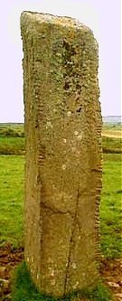
Doonfeeny
or
Dunfeeny: Standing-stone and Promontory-fort
3.2 km NW of Ballycastle, to the SE of a track running SW from the coast road, this impressive square-sectioned, slightly-leaning pillar stands over 5 metres high. It is a fine example of a pre-Christian monument which was Christianised some time before the 12th century - by two crosses (one with birds' head designs) at the bottom., and by monastic settlement. From it fine views can be had of Doonbristy, a stack (or headland cut off by the sea) on which are the remains of a promontory-fort.
Rathlackan: Single-court tomb
Situated just S of a conifer-plantation and less than 200 metres to the W of a by-road, this tomb emerged recently from the peat-bog which preserved it. As one might expect in county Mayo, it is an exceptionally well-preserved example of a court-tomb, retaining its roofstones and the entire cairn, even if the orthostats are not very tall. No door-stone has survived. It was recently discovered only because a standing-stone was investigated and found to be a tilted roofstone. Four men and three women lifted the slab with wooden poles and ropes and replaced it in about an hour! ~ 6 km SSE is the wedge-tomb at Rathfranpark , and 800 metres SSW of it, another court-tomb at Carbad More.
~ 5 km SSE is
Breastagh
ogam-stone.
Srahwee: Wedge-tomb
9.6 km S of Louisburgh, immediately NE of the road and Lough Nahaltora (Altar Lake), this well-preserved sepulchre is in a very beautiful situation by the roadside. A single large roofstone covers most of the main chamber of the gallery, which is 4.2 metres long. Double-walling, a fine large septal slab, and traces of the cairn survive. As 'The Altar Well'
(Tobernahaltora)
it was formerly venerated as a holy well!
|
![]()