![]()

|
county list
|
| Court-tombs = Portal-tombs = Wedge-tombs = Passage-tombs = Stone Circles | France | |
|
|
Tell-A-Friend
|
GAZETTEER of
IRISH PREHISTORIC MONUMENTS |
|
SELECTED MONUMENTS IN
Place-names in italics refer to listed entries.
Ahaglaslin: Portal-tomb
click on the thumbnail for a larger picture
Conspicuously sited across a little valley E of the Clonakilty-Rosscarbery road on a ledge of the hillside 2.4 km E of Rosscarbery, and approachable through a farm to the SW of a by-road leading SW off the Rosscarbery-Clonakilty road to the NE of the tomb.
~ A little over 850 metres to the N is Bohonagh axial-stone circle.
Arderawinny: Portal-tomb
click on the thumbnail for larger pictures
This picturesque tomb is 4 km WSW of Skull and about 90 metres N of the road from Skull to Toormore Bay. in a little hollow, facing into a low cliff.
~ 1.6 km WSW and 20m to the W of the same road, where it meets Toormore Bay, in Altar (V 858 303) is a Wedge-tomb one of whose 2 capstones has slipped and is now leaning against the front (W) end of the tomb. It is 2.4 by 2.2 metres with a square piece (? intentionally) knocked off. The other capstone is 2.7 by 2.1 metres. Some of the low orthostats and nearly all of the cairn are missing. Excavations in 1989 showed that the tomb had continuous activity surrounding it from around 2000 BCE to 1400 AD! ~ Just over one km NNW in Toormore , immediately S of the R.951 is another ruined wedge-tomb, excavated in 1990. No traces of a covering cairn were found. Five separate 'depositional events' occurred between 1800 and 1600 BCE, soon after the construction of the monument. ~ 17.7 km NE are the petroglyphs at Ballybane .
Ardgroom Outward: Stone Circle
click on the thumbnail for larger pictures
Commanding a fine view from its exposed position over Bantry Bay 7.2 km WSW of Lauragh Bridge and about 500 metres SSE of the R 571 road, approachable by farm-lane and across bogland, this fine axial-stone circle has stones similar to the pillar-like slabs of the smaller circle at Drombohilly (Kerry), 9.6 km NE. In this circle also 9 stones survive, with some unfortunately missing: one can be seen in a field-fence some distance to the N. They range from l30 cm to almost 2 metres in height. Outside the circle, to the E, is an associated standing stone. The axial stone is, unusually, set with its long axis vertical.
~ 3.2 km W is the tall Ogham-inscribed standing
~ 9.6 km S by W is another fine circle at Derreenataggart West. ~ Less than 4.5 km E is Shronebirrane stone circle, Kerry. ~ Less than 4.5 km NE is a 5-stone circle at Cashelkeelty (V 748 573).
Ballybane: Petroglyphs
9.6 km SE of Bantry and l.6 km SSW of Ballybane House, immediately to W of a by-road on a sharp bend, a large area of horizontal rock surface (not pitted like most of the surrounding surfaces) is decorated with circles and ovals up to 60 cm in diameter, at least one cup-mark and several long straight lines, some of which are parallel. The grooves are unusually wide.
~ The map indicates another group a couple of hundred metres NNW. ~ 17.7 km SW is Arderawinny portal-tomb. ~ 17.5 km SE are Gurranes alignment and Rathdrum fort.
Ballyvourney: Monastic Site, Cross-pillar, etc.
This site, 13.6 km WNW of Macroom, beside a by-road leading S from the N 22 road between Ballyvourney and Ballymakeery, may be of extreme antiquity. 'St Gobnait's House' or 'St Gobnait's Kitchen' is a circular hut (partly restored) with an internal diameter of 6 metres. It was occupied in the Early Christian period by workers in bronze and iron-smelters. In the graveyard across the road is "St Gobnait's Grave": a small mound with 3 bullaun stones and the abandoned crutches and offerings of hopeful pilgrims. Ballyvourney is the scene of a
'pattern'
still performed, and St Gobnait, a virgin whose emblem is the fertility symbol of the bee, is credited with the cure of the sick. (A legend connected with St Gobnait has given the name to the townland of Lackavihoonig: the flagstone of the thief. The saint fastened the thief and the cow and calf he stole on to the flagstone on which they were standing at the fateful meeting. The stone has the imprints of feet and hooves upon it.)
~ About 1.2 km ESE in a glade in Shanagloon townland are "St Abban's Grave" (a small cairn), a bullaun stone, and three Ogam stones. A fourth has been removed. The others have been deliberately chipped. ~ At the other side of the main road, in the middle of a large field 800 metres down a byroad (first turn on left past Ballymakeery if going in the direction of Macroom) is "St Gobnait's Stone", found at the site of a dry Holy Well nearby. It is a fine cross-pillar some 90 cm above ground, bearing on each face a cross-pattée of arcs inscribed in a double circle. On one face this is surmounted by a small crozier-carrying figure with parted hair, resembling a portrait in the Book of Durrow. ~ 2.4 km NNW of Ballyvourney, E. of a lane leading from the main road towards Lough Carrignafurark, in Slievereagh , are 2 large, pointed stones 3.3 metres and 1.2 metres high, whose parallel perpendicular faces are only 70 cm apart. Behind them is a low slab, apparently for support. Two stumps lie on either side of the stones, making the monument appear like the remains of a tomb.
Bealick: Wedge-tomb
2.8 km ENE of Macroom and 9.6 km W by N of Coachford, up a tarred lane and over 3 fields to the N. In a field about 400 metres from the river Laney and 1.6 km NE of Macroom (New) Bridge stands a small, denuded tomb with a large capstone 360 by 210 cm and 45 cm thick, and a wide, natural groove running its entire length. The overall height of the tomb is 1.5 metres.
Beenalaght: Stone-row
This is the best-known alignment in the area, 13.6 km SW of Mallow, on a hill to the W of the Mallow-Coachford road about 1.6 km SW of Bweeng. Known as 'An Seisear' (The Six), five stones from 1.8 metres to 3 metres high are standing, while a sixth is prostrate.
The area is rich in prehistoric remains, especially Standing-stones. ~ 1.6 km S by W is Gowlane North Stone Circle. ~ 3.6 km NNW is another alignment in Garrane .
Bohonagh: Stone Circle and Boulder-burial
click on the thumbnail for a larger picture
Situated 2.4 km E by N of Ross Carbery, to the NW of the road from Ross Carbery to Clonakilty, halfway between it and the byroad leading to Quaker's Crossroads, four out of the original 13 large stones of this impressive circle are missing, and 3 were re-erected after excavation. The 2 portal stones are 2.4 metres high and are set radially. The axis from these to the large axial-stone on the W side points to sunset at the equinoxes.
~ 20 metres E of the circle is a boulder-burial, whose large capstone has seven or more small cup-marks on its upper surface. Two of the three small supporting stones are of quartz; a fourth has been uprooted. A loose slab nearby also bears cup-marks. The complex, which included a rectangular wooden house (excavated) was revealed to be of Bronze Age date, as might be expected.
~ 800 metres SW and 1.5 km) E of Rosscarbery, a short distance W of a byroad in Burgatia (W 303 355), is another boulder-burial, comprising a large boulder resting on the inner edges of 2 flat-topped blocks, one of which is a quartz conglomerate. ~ 800 metres S of Bohonagh is Ahaglaslin portal-tomb. ~ Other nearby stone circles are at Knocks , (W 299 457), Drombeg and Reanascreena South .
Cabragh: Stone-rows and circle
This is a group of monuments, 10 km due S of Millstreet and 9.6 km NW of Macroom, and 4 km WNW of Scrahanard wedge-tomb, to the E of a long track leading to Carriganirtane. About 150 metres E of the track is an alignment 9 metres long of six stones 90 cm apart, two of which have fallen. The tallest stone still standing is 180 cm high; the southernmost stone (fallen) is 275 cm long. ~ A few hundred metres up the track, but not visible from it, is another alignment, connected perhaps with a (?) tumulus about 100 metres E of the track, of four stones, grooved on top, l metre apart, and respectively 3.3, 2.75, 2.4 and 2.1 metres high. ~ About 90 metres away, along the same axis in a westerly direction (i.e. towards the track) is a fifth stone just over 150 cm high. Close to the E end of the alignment is a 5-stone axial-stone circle, whose two portal stones are still visible; two other stones are incorporated in a field fence, and one stone is missing. S of the tumulus is an isolated standing stone 1.5 metres high. ~ North of the second alignment, farther up the hill, is a third. ~ 800 metres N, just S of the summit of Carriganirtane hill, in Carriganirtane is a fine low wedge-tomb nearly 4 metres long with 3 roof stones and some double-walling on both sides. ~ On the W side of the track leading up to Cabragh and Carriganirtane, in the townland of Clashmaguire can be seen a pair of standing stones which seem to fit into the category of male-and-female.
Caherurlagh: Holed Stone
6 km WSW of Kilcrohane, about 120 metres N of the road to Sheep's Head, near the townland of Ballyroon. Caherurlagh is a very small townland, and once it is located, the stone can be found with local help. It is now lying prostrate on the W side of a field fence which occupies the site of a stone fort. The entrance to the field is said to be the entrance of the fort. The half-buried stone is 2.25 metres long and the hole is 13 cm in diameter and 12 cm deep. The centre of the hole is 43 cm from one end and 13 cm from one edge. The house nearby used to be occupied by a healing man who, amongst other cures, made a barren sow fertile by laying a hand on her through the hole. The stone has lain prostrate for at least 70 years.
~ (For other
holed stones
see
Doagh
, Antrim
Carrigagulla: Stone Circle
Surrounded by an amphitheatre of hills, 2.8 km N by E of Ballynagree and 11.2 km NNE of Macroom, about 150 metres to the E of a good track leading up to the monument-rich Boggeragh mountains, at a point where the track dips into a valley, this fine axial-stone circle, 8.2 metres in diameter, comprises sixteen stones and a misplaced one. They vary in height from almost 90 cm down to just over 30. Unusually, the long, straight-edged axial stone is not the lowest; the highest is next to the lower of the two portal stones. In the middle of the circle is a boulder.
~ About 250 metres N, in the next field, at the edge of a coniferous forest and near the river Laney, is another circle of classic 5-stone, D-shaped type, whose axial stone has a (naturally) bevelled upper surface. ~ Just under 1 km S is an alignment of 3 stones (W 371 829), and another just over 1 km E (W 383 829). ~ Just over 2 kms SE is Oughtihery stone circle (W 391 821), a very neat five-stone construction just 3.2 metres in diameter, with field-stones dumped inside.
~ 2.4 km ESE is Knocknagoun wedge-tomb. ~ 9.6 km SW is Scrahanard wedge-tomb.
Castlenalaght: Stone-row and Boulder-burial
click on the thumbnail for a larger picture
5.6 km N by W of Bandon and about 70 metres W of a by-road, this superb alignment commands fine views and comprises 4 stones increasing in height from 2.2 to over 3.4 metres. A prostrate stone between the two smallest is not original. In the next field, 400 metres to the N, is a boulder-burial: a large rounded boulder is set on 3 supporting stones between 40 and 60 cm high, and a little above a fourth stone. ~ Just under 12 kms W by N, to the S of a by-road in Knocknaneirk (W 371 626), is a fine five-stone circle, 11 metres in diameter, with two large portal-stones and a long axial stone with a straight upper edge. In the middle is a ruined cairn.
Coolineagh: Ogam Stones
Less than 20 metres SE of the ruined church of Aghabulloge, 7.2 km NW of Coachford, to the E of a by-road leading NW of the road from Aghabulloge to Rylane Cross, is a damaged Ogam stone 1.5 metres high, also bearing 3 plain crosses, and crowned with Caipín Olainn (St Olann's Cap), a lump of quartzite. Originally there were two superimposed stones, but because of the phallic character and popularity of the monument (as a cure-stone for barrenness, headaches, etc.) a local priest removed them. They were promptly replaced by the present caipín . ~ 135 metres N, in a field, is "St Olann's Stone", a boulder with "the Saint's Footprints". ~ About 400 metres NNE of the church, by the W side of the road from Aghabulloge to Rylane Cross is "St Olann's Well", a corbelled, clochán-like well-house with an ivy-covered hawthorn-tree growing out of it. Nearby is a second Ogam stone, just under 2.7 metres high, which reads RQIDEGO. On the 5th of September there is a pattern around the caipín , stone, and well. This is evidently a site of great antiquity, only superficially Christianised. The country round about is littered with stone circles, standing stones, souterrains, and Ogam stones: ~ 3.8 km NNW is Knocknagoun wedge-tomb. ~ 9.6 km NNE is Beenalaght alignment. ~ 11.2 km W are the monuments around Scrahanard wedge-tomb.
Derreenataggart West: Stone Circle
Situated 1.2km WNW of Castletown Berehaven and 50 metres N of a byroad leading N off the main road. eight of the post-like stones of this neat circle are standing, including one of the radially-set portal stones. The other portal stone has broken, and three other stones of the circle have fallen. The axial stone is a fine long slab 1.2 metres high and 2.1 metres long.
~ Just over 6.4 km N by W is the tall Ogam-inscribed standing stone at Faunkill-and-the-Woods. ~ A little over 8 km E by S, in Ardaragh on Bear (or Bere) Island (linked to the mainland by-road) is a wedge-tomb) close to a lane from the old British naval rifle range to Rerrin hamlet. It comprises a collapsed main chamber about 5 metres long, the front (W) end of which is a short portico or antechamber with a septal stone 130 cm high.
Drombeg: Stone Circle and Cooking-place
click on the thumbnail for a larger picture
Thirteen out of the original 17 stones of this impressive circle (2.4 km E of Glandore, 250 metres down a path to the E of a byroad) survive, the most westerly of which is the fine axial, which has two egg-shaped cup-marks, one with a surrounding ring. The two portal stones (1.8 metres high) are as usual on the NE side. Radio-carbon tests on the cremated burial found in the centre of the circle gave a date between 150 BC and 130 AD, though the circle itself is almost certainly Bronze Age. The long-continued use and re-use of sacred sites is not uncommon in Ireland (see Altar under Arderawinny , above). ~ Just over 30 metres to the W are the remains of 2 conjoined round huts, the larger of which had a timber roof supported by a central post. The smaller hut had a cooking-oven on its E side. From the huts a causeway leads to a cooking-place containing a hearth, a well, and a trough in which water was boiled by dropping in hot stones almost 350 litres could be boiled within 15 minutes of the stones being dropped in. The presence of the stone circle, huts, and cooking-place suggests that annual or seasonal gatherings took place at a sacred site down to the fifth century AD, the dating obtained for the cooking-place. ~ The stone circles of Bohonagh and Reanascreena South are not far away.
Farranahineeny: Stone-row
This fine alignment, 1.6 km W by N of Poulnaberry Bridge, comprises five stones (some broken), ranging from 1.4 to 3 metres high. It is beautifully situated and commands a splendid view.
~ 2.4 km ESE, in Inchincurka (W 234 596), 1.6 km E by N of Poulnaberry Bridge and 150 metres (in the second field) N of the road, is a wedge-tomb. Though it has been used as a dump for field-stones, its state of preservation and accessibility make it worth visiting. The narrow wedge-shaped gallery is covered by two overlapping roofstones. Its characteristic flat façade is well represented, and much of the outer walling survives. There is no evidence, however, of a portico or antechamber. ~ 8.8 km N by W of Inchincurka, about 500 metres W of Cloghboola Bridge, and about 85 metres N of the road, in Cloghboola , is a small neat wedge-tomb, one metre high with a capstone 2.4 by 1.5 metres, hidden, unfortunately by a Forestry plantation.
Faunkill-and-the-Woods: Ogam Stone
~ 300 m SSW (a short distance SW of the main road) is an axial-stone circle of eight very low stones at the end of a low mound. ~ 3.2 km) E is the stone circle at Ardgroom Outward . ~ Just over 6.5 km S by E is another circle at Derreenataggart West.
Garrane: Stone-row
3.2 km NW of Bweeng and 11.2 km SW of Mallow, just visible on the rising slope 200 metres S of a T-junction at the bridge over the Duvglasha river, this fine alignment (or stone-row) offers a panoramic view across the valley of the river Blackwater. It comprises three stones close together and measuring from 2.5 to over 3.7 metres high. A fourth one has fallen.
~ 2.4 km NNW, about 900 metres E by N of Lahuran crossroads, in Gneeves , is another, unusual, alignment of 3 stones whose broad faces are parallel, but not in line. The highest is 2.6 metres.
~ 1.6 km due S, and 20 metres NE of the road from
~ 3.6 km SSE is Beenalaght alignment.
~ 7.2 km ESE is
Kilquhane
holed stone - see under
Glantane East: Wedge-tomb and Stone Circles
6.4 km S by E of Millstreet, visible to the W of a byroad running N and skirting a forestry plantation, this neat little wedge-tomb (known locally as "The Flags") stands 90 cm high in a field, and has a capstone 2.4 metres square, resting on two sidestones and a back-stone. Some of the double-walling survives, and a small stone 40 cm high stands between the two side-stones.
~ In the next field to the NW is a stone circle almost 5 metres in diameter, five of whose stones are still standing and six have fallen, some into the surrounding ditch, part of which at least is faced with stone. There are two outliers. In the middle of the circle is a large hole, where presumably a boulder or boulder-burial stood
~ 400 metres SSW, W of the lower road, beside a derelict (maybe now rebuilt) house, up a grassy lane bounded on the N side of spruce-trees, and itself surrounded by trees, in the same townland (W 280 833) is an axial stone circle, 4.7 metres in diameter, of ten stones and a loose flagstone lying beyond the axial stone. The portals opposite the axial are 81 cm high.
~ On the opposite side of the lower road, some 800 metres SSW of the wedge-tomb is an alignment of three stones, one being 2.4 metres high and the other two (broken) surviving to a height of 90 cm.
~ 3.2 km NNE is a five-stone circle with outliers and a cairn (similar to the Kealkil complex) at Knocknakilla (W 297 841). It has good portal-stones. One of the outliers (over 4 metres long) to the SW of the circle has fallen, but the farther one, though leaning, stands 4 metres high. ~ Just over 1 km SE is a five-stone circle at Carriganimmy (W 293 827). ~ 4 km S are Cabragh stone-rows and five-stone circle (W 278 798).
Gowlane North: Stone Circle
1.7 km S by W of Beenalaght alignment and 3.2 km N of Donoughmore, 400 metres W of the road and at the bottom of the second field NW from a pair of field gates is a perfect circle, 7 metres in diameter. It comprises eight stones (two fallen) averaging one metre in height, two of which, only 90 cm apart, form an entrance to the N with another pair set radially outside the circle, slightly farther apart. This entrance passage, 2.1 metres long, faces a large axial stone: a rectangular slab 150 by 90 cm on the opposite side of the circle.
Greenhill: Ogam Stones
8 km SSE of Mallow, and about 300 metres S of a by-road, by a hedge on the W side of a field is a large fragment of an irregular block on which the clear inscription CATTUBUTTAS MAQ. . . survives. About 40 metres further, on the other side of the hedge and bank is a fine, large, tapering stone 2.4 metres high, on which is the inscription TRENU MAQI MUCOI QRITTI , together with deep grooves above and below the N, and other grooves made recently by vandals. Quartz pebbles abound nearby. ~ In the middle of a field about 200 metres E of the second stone is a fine standing stone 1.8 metres high, with a remarkably smooth E face. ~ 5.6 km SW, 9.6 km S by W of Mallow, almost opposite the ruins of a church, and about 10 metres N of a by-road, in Kilquhane , is a holed stone, now prostrate, 1.80 metres long, 70 cm wide and 25 cm on its thick side. Near the thin edge of the stone, 73 cm from the near end and 56 cm from the thick edge, is an irregular hole from 6.2 to 11.3 cm across, and of a depth varying from 5 to 19 cm. This stone, known as "The Sinners' Stone" (Cloch na pecaib), was resorted to by pregnant women, who pulled pieces of cloth through the hole to ensure easy (or at least safe) delivery. ~ Another holed stone is at Lackendarragh, 7.2 km WNW of Kilquhane (see under Garrane above). ~ 2.4 km SE of the Greenhill Ogam stones is the fine wedge-tomb at Island .
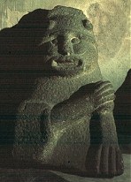
Gurranes: Stone-row
click on the thumbnail for a larger picture
~ 17.7 km NW are the petroglyphs at Ballybane.
Island: Wedge-tomb
8.8 km SSE of Mallow and 1.2 km E of Burnfort, to the W of a by-road, approached up a lane and through a farmyard, this is a fine example of a small wedge-tomb, excavated in 1957. The gallery, 6 metres long, and facing SW, is a single chamber, bounded by typical double wall of stones. Parallel to the gallery is the heel-shaped kerb which connects with the flat façade of the tomb. The thin roof-stones are in situ, and much of the cairn material survives between the gallery and the kerb.
Kealkil: Stone Circle, Standing Stones and Cairn
800 metres SE of Kealkill village and about 180 metres NE of a sharp steep by-road, the tops of the standing stones are just visible from the road. This impressive and splendidly-situated monument (overlooking Bantry Bay and Kealkill village) comprises a fine 5-stone axial circle of large stones, with 2 outlying monoliths, the higher of which is now almost 4 metres high. It was originally over 6 metres high. This is one of the few circle sites to have been excavated, and inside the circle was found a setting of crossed timber sleepers which may perhaps have held anupright of wood or stone. Like most stone-rows, the two outliers are on a NE-SW axis, parallel with that of the circle. Nearby also is a small cairn of stones incorporating a circle of small upright stones set radially (see also Knockraheen under Scrahanard).
~ Just over 400 metres SW of The Kealkil monuments, in the third field on the opposite side of the road, in Breeny More (W 050 552) are the remains of a large multiple-stone circle enclosing four boulder-burials set in the form of a rectangle. The circle must originally have been impressive, but the only stones now standing are the entrance stones, the axial stone (overthrown) and three others. The boulder-burials are good examples, all with large cover-stones. The standing stones of Kealkil can also be seen in the distance to the NE. ~ 5 km ENE is one of two stone circles in Maughanaclea (W 104 565), easily accessible by a farm-lane. It is over 10 metres in diameter and contains two boulder-burials. Twelve of the original 13 stones survive, five of them fallen.
1.5 km E by S of the first circle, is another (W 090 563) immediately W of a tarred track is a five-stone circle with an outlier 2.4 metres high. ~ 7.2 km W by N are the boulder-burials, standing stones, and stone circle at Mill Little.
Keamcorravooly: Wedge-tomb
75 metres S of a byroad, opposite a small plantation of spruce trees on either side of the road, some 11.2 km SSW of Ballyvourney and 800 metres WSW of the Bansheelin river, "The Giant's Grave", (An Uaigh an Fhathaigh) , is a neat and picturesque tomb about 3.6 m long, with two overlapping roof-slabs, the easternmost of which is supported by a small chocking-stone on top of the backstone. It is markedly wedge-shaped, and retains much of its double-walling. Like most of the Cork wedge-tombs it is low, the entrance being about 106 cm high. It commands a fine view of the hills to the N and W. About 200 metres further up the hill, on a ridge, is a second, ruined, wedge-tomb. The large field in which they stand has been planted with forest which probably now hides the tombs.
Kilmaclenine: Megalithic Tomb
Known as 'Acuthogue' , and situated 4.8 km SW of Buttevant and 1.2 km ENE of Kilmaclenine Crossroads, on the left hand side of a lane leading NNW from a byroad, this box-like tomb (an enormous kist ?) was opened in the last century and found to contain 'a skeleton, a sword and some beads'. The roofstone is over 2.75 metres long, supported on two sidestones and a backstone almost 1.5 metres high.
Knockdrum: Stone Fort, Souterrain, and Cross-pillar
1.2 km W of Castletownshend, on the S side of the road, opposite Gurranes stone-row, approached by a path and steps, this fort was restored in the last century and encloses an area 22 metres across. In the middle is a roofless square stone hut, from one corner of which a 3-chambered lintel-roofed souterrain runs through hewn rock. Just inside the entrance to the fort is a cross-pillar (presumably found nearby and erected here by the restorers). Outside the entrance, and probably not directly connected with the fort, is a large boulder bearing about 40 cup-marks, dating from the Bronze Age. On the right hand side of the entrance passage is a small guard-chamber. ~17.7 km NW are the petroglyphs at Ballybane .
Knocknagoun: Wedge-tomb
10.4 km NNW of Coachford and 2 km N of Sheskinny Cross, 60m E of a track, a quaint, low tomb, with a gallery about 2.1 metres long, closed at the E end, is covered by 2 capstones. The larger (2 metres long) overlaps the smaller, and they rest on 6 sidestones and a backstone. Round about is some evidence of a cairn. Up to the end of the last century it was completely covered by cairn stones. Attempts to destroy the sepulchre led to several misfortunes, and only the cairn and most of the outer walling have been removed.
Labbacallee: Wedge-tomb
2 km SE of Glanworth and 8 km NW of Fermoy, by the roadside, over a wall, this is the largest of Irish wedge-tombs. Three huge capstones (the largest being nearly 8 metres long and weighing 10 tonnes) slope downwards towards the back. The gallery consists of a large rectangular chamber, with a small one behind it, separated by a dividing slab, one corner of which has been trimmed off to leave a 'half-porthole'. The gallery is triple-walled, and buttressed at the back by 3 slabs set parallel with the tomb's axis. In front of the gallery are the remains of a large rectangular, unroofed portico or antechamber, wider than the gallery and cut off from it by a large slab. It is one of many tombs especially wedge-tombs to be (latterly) associated with the Celtic Hag-goddess also known as Caillech Bhéarra : Labbacallee (Leaba Caillighe) means "Hag's Bed". Other tombs are associated with the lovers Dermot and Grania in the folk tradition. The sepulchre resembles a French gallery-tomb in size and design, a similarity shared by the wedge-tomb at Burren , Cavan.
Lettergorman: Stone Circle
Less than 800 metres SE of Lough Atariff, about 50 metres S of a narrow by-road, the 5-stone circle is 3 metres in diameter, and has stones up to 150 cm high. The axial stone is 5 metres long. One portal stone has fallen, as has a large quartz monolith. ~ A rare Irish "four-poster" circle lies in the same townland (W 267 473, marked Standing Stones ), 1.75 km NNE. ~ 800 metres NW, and 5 fields in from a derelict house on the left of the same byroad, in Knockawaddra , is an alignment of four stones, in descending height, the highest of which is 3.5 metres, commanding a view over the Glashagloragh river valley. When ploughing the adjacent field a farmer observed 'a bright red streak in the soil' extending eastwards from the stone-row. ~ An axial stone circle can be seen at Carrigagrenane (W 254 432). ~ 3.6 km E of the Lettergorman Southwest circle, and 150 metres (second field) S of the Clonakilty-Dunmanway road, in Knocks (W 300 456), is yet another circle. It has 2 good portal stones, with 5 others visible, and the axial stone is embedded in a fence. The farmer on whose land the circle stands cleared the field and dumped the stones in the circle, which local opinion considered to have been the cause of the mysterious deaths of his cattle. ~ 2.4 km S by W of the first Lettergorman circle is another circle at Maulatanvally (see under Reanascreena South ).
Mill Little: Stone Circle and Boulder-burials
7. 2 km due E of Glengarriff, and 100 metres W of the south-flowing Cooleenmane River, 50 metres W of a tributary stream which joins the river at Millbeg Bridge to the E, this 5-stone circle was unusual in having the entrance stones (now disappeared) set roughly parallel to form a short entrance passage a feature sometimes occurring in multiple-stone circles. W of the axial stone is a boulder-burial, 125 cm high, whose rounded cover rests on three supports. S of this is another boulder, possibly the cover of a second burial.
~ 7.2 km E by S, are the stone circle and standing stones at Kealkil.
Reananerree: Stone Circle and Alignment
4.8 km S of Ballyvourney, 300 metres SE of Reananerree Church and 200 metres E of the road to Ballyvourney, in the middle of a large field is a very small 5-stone circle (or rather an oval) 2.6 metres in maximum diameter, with small stones ranging from 30 cm (the axial stone, in the foreground) to 85 cm in height. ~ 120 metres SE of the circle is a circle of six stones (marked Stone-row on the map) decreasing in height from 150 to 50 cm. It is unfortunately divided in two by a stone fence and a line of spruce trees, but once commanded a fine view. ~ 1.5 km NNE, and 500 metres ESE of the site of demolished Gortanimill House, near the top of a rock outcrop about 80 metres E of the by road from Reananeree to Ballyvourney, in Gortanimill (W 208 741), is a multiple-stone circle of 12 stones about 90 cm high enclosing an area 7.5 metres in diameter, with 2 small quartz boulders in the centre. The site commands fine views, and is one of the few circles which can be viewed from above.
Reanascreena South: Stone Circle
4.8 km NNW of Ross Carbery and 800 metres NW of a byroad at a height of 170 metres, a circle of twelve large stones (2 forming a portal, with the axial stone opposite) is surrounded by a low earthen bank with a shallow ditch, similar to the circle at Glantane East. The axis points WSW and thus, unlike the nearby circles of Bohonagh and Drombeg does not relate to the sunset at either solstices or equinox. ~ There are several other axial-stone circles in the neighbourhood, including one which is 3.2 km due N of the Reanascreena site and 100 metres E of a byroad in Maulatanvally. Only seven stones survive, including one portal stone 140 cm high. Small quartz pebbles surround a central white quartz boulder. ~ Another stone circle is at Carrigagrenane (W 254 432). ~ A five-stone circle is at Lettergorman Southwest (W 262 456), and a rare Irish "four-poster" circle at Lettergorman Northeast (W 267 473).
Roovesmore: Stone-row
3.2 km S by W of Coachford, in fields to the S and W of a byroad, situated tangentially between two raths (Iron Age farmsteads) this strange alignment is about 400 metres long. The stone nearest to the road (originally almost 3 metres high) is now prostrate and broken in two. It may have been a single standing-stone. In the next field, to the SSW, is another prostrate stone 4.8 metres long beside a large boulder and a notched, leaning upright stone 3.1 metres high. In a third field, also to the SSW, is a cup-marked stone 1.6 metres high, together with a greatly cup-marked boulder. The fort on the other side of the road to the NNE end of the stone-row (marked Ogham Stones on the map) has a deep ditch between two banks and a line of three low boulders outside it. The entrance of this fort, the first standing stone, and the smaller overgrown fort are all in line - which may or may not be fortuitous.
Scrahanard: Wedge-tomb
6.4 km N by W of Macroom, by a field-fence immediately to the W of a narrow byroad from Carriganimmy to Macroom, 500 metres NW of a junction, "The Bealick" is a brambly tomb with a capstone 2.3 metres by 2 metres wide. The backstone of the gallery, and the sidestones adjoining it, have scratched marks on the inside face, more lightly incised than those at Baurnadomeeny , Tipperary. Crosses were scored on the outside face of one of the stones in the last century. In the same field stands a single slab and also what looks like an untouched cairn. Beyond the cairn is a souterrain. ~ 70 metres SE of the circle is a cairn with radial stones on its perimeter, surrounded by a ditch and an outer bank. Two other cairns lie about 130 metres NE of the circle. The group seems to have been a large single ritual complex (compare Kealkil ). ~ The area around Macroom and Coachford is very rich in prehistoric remains, especially standing-stones and stone-rows. ~ In the adjoining townland of Lackaduv , on the other side of the road, approached by a track opposite "The Bealick" and situated on a rocky slope, is an impressive wedge-tomb. The capstone is 2.4 metres long and 1.8 metres wide. Much of the double-walling has survived. ~ In Knockraheen , 1.6 km NNW of "The Bealick", a short distance to the N of the same road (W 303 802) is a stone circle of five stones pointing to the S, with remains of an alignment (two quartz stones still standing and a third prostate) on the same axis. From here, amid a dramatic landscape, can be seen the two large standing stones on the ridge of Knockraheen mountain. 30 metres NNE is a cairn with two standing-stones to the NNW; 60 metres SSE is a "radial cairn". ~ 4 km W by N of "The Bealick" are two stone-rows in Cabragh . See also under Glantane East .
Templebryan North: Stone Circle
Immediately E of the road, 4 km N of Clonakilty, are the remains of a fine large stone circle, of which only 5 large stones all flat-topped out of a probable 9 now survive. These include the axial-stone, and one of the portals which is almost 2.1 metres high. In the middle of the circle, which is about 10 metres in diameter, is a quartz boulder.
~ Some 300 metres NW is a neglected enclosure containing graves, a ruined square oratory, a souterrain, a holy well (Tobernakilla') , a bullaun , and a fine tapering monolith 3.3 metres high, low down on whose W face is a worn cross-pattée and a faint Ogam inscription reported to read ANM TENAS MACI V. . . They were both carved on an existing standing stone which may have had some connection with the stone circle.
|
![]()


